|
This excerpt from a 1926 U.S. Geological Survey topographic map shows several standing structures in the area of the town site of New Philadelphia. This map was based on information from surveys conducted in 1921 and 1924. The approximate perimeter of the town's lots is depicted by the red rectangle. The symbol for the location of a Philadelphia School house is located immediately to the right of the word "School" on this map. Compare this 1926 map with a 1939 aerial photograph that shows the same terrain and a number of standing structures. |
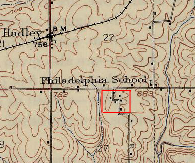
Source: 1926 Topographic Map, Pittsfield Quadrangle, U.S. Geological Survey; University of Illinois Historical Map Collections, http://images.library.uiuc.edu:8081/u?/maps,2086.Maintained by |