Map and Deed Records
of New Philadelphia, Illinois

Excerpt from Atlas Map of Pike County, Illinois, 1872
and Deed Records for New Philadelphia


dividing bar

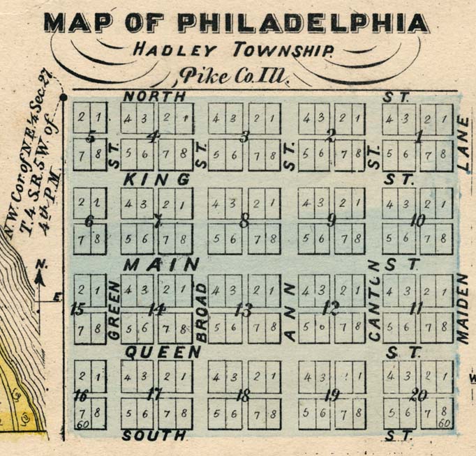
This excerpt from the 1872 Atlas Map of Pike County shows the town lots and streets of Philadelphia, and depicts the lot designations in a manner consistent with the original plat laid out by Frank McWorter in 1836. (The drawing of a river's edge along the lower left margin of this image is from an adjacent inset map unrelated to Philadelphia.) This Atlas also provided a map of the vicinity surrounding Philadelphia.

Click on each Block in the map below to see a record of landowners over time for each of the lots in that block. You can also use our search engine to look for particular names throughout the records presented on this web site, including deeds, census lists, tax records, and newspaper archives.

1872 town map excerpt

Source: D. W. Ensign, Atlas Map of Pike County, Illinois, Davenport, Iowa: Andreas, Lyter & Co., 1872, p. 84. Illinois Historical Survey Collections, University of Illinois, Urbana-Champaign.

dividing bar


1872 Map of Philadelphia Vicinity

Aerial Photograph with Plat Overlay

Return to New Philadelphia page

Map and Survey Index

Maintained by
Christopher Fennell

Block 1 Block 2 Block 3 Block 4 Block 5 Block 6 Block 7 Block 8 Block 9 Block 10 Block 11 Block 12 Block 13 Block 14 Block 15 Block 16 Block 17 Block 18 Block 19 Block 20