This web site presents excerpts of survey, cartographic, and photographic information on the Illinois, Pike County, and New Philadelphia regions. Go to our Web 2.0 portal if you'd like to view and comment on such sources using more interactive media, such as our group Flickr site.
|
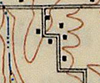
Click on the image on the right to see an excerpt of an 1830 land survey of Hadley Township in Pike County, including the tract on which New Philadelphia was established.
|

|
|
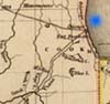
Use the image on the left to see an excerpt of an 1845 map of Illinois and the expected impact of the Illinois-Michigan Canal on land development throughout the Illinois River valley.
|
|
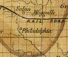
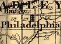
Use the image on the right to see an excerpt of an 1861 map of the Pike County area, including the town of "Philadelphia." |
|
|
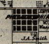
Click on the image on the left to view excerpts from an 1872 map of Hadley Township, including Philadelphia, surrounding properties, and the nearby town of Hadley Station, and a similar map from an 1860 Atlas.
|
|
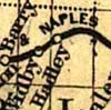
Use the image at the right for an excerpt of an 1872 railroad map of Pike County, showing the Hannibal and Naples Railroad line.
|
|
|
Use the image at the left for an excerpt of an 1875 map of Pike County, including New Philadelphia and the nearby towns of Hadley Station and Barry.
|
|
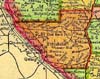
Click on the image at the right to see a larger view of the area around Pike County from an 1895 atlas. New Philadelphia was situated a few miles southeast of Barry (established in 1836) and about one mile southeast of Hadley Station (established in 1870), both of which are visible on this map.
|
|
|
Use the image at the left to view an excerpt from a 1926 topographic map of the New Philadelphia area, based on surveys conducted in 1921 and 1924.
|
|
Use the image at the right for views of the area around the former location of New Philadelphia from a 1956 landform map by the Illinois State Geological Survey.
| 
|
|
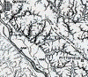
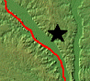
Click on the image at the left to see the topographic relief of the area around Pike County, in which New Philadelphia was located (in the area marked by the star). An accompanying satellite image shows the same region. |
Chronological Index
1820 Map of Military Bounty Land in Illinois
1830 Federal Surveyor's Map of Hadley Township
1836 Map of Illinois
1836 Town Plat
1845 Map of Illinois Showing Canal Improvements
1845 Map of Illinois from Morse's North American Atlas
1860 Atlas Map of Pike County
1861 Sectional Map of Illinois
1872 Map of New Philadelphia with Deed Information
1872 Atlas Map of Pike County
1872 Railroad Map of Pike County
1875 Atlas of Illinois Counties
1876 Map of Pike County
1879 Map of Illinois
1895 Atlas of the United States
1897 Map of Illinois
1926 Topographic Map
1956 Landform Map of Illinois
1939 Aerial Photograph with Crop Notations
1939 Aerial Photograph without Crop Notations
1939 Aerial Photograph with Town Plat Overlay
1990 Topographic Map, Large Scale
1990 Topographic Map, Medium Scale
1990 Topographic Map, Close Scale
1998 Aerial Photograph
1998 Aerial Photograph with Town Plat Overlay
2005 Aerial Photograph
Satellite Images of Region
|